Oroville Dam is about to face its next big test as a new storm moves into the area

Engineers and construction crews worked furiously to fortify the Oroville Dam’s damaged spillways and crippled power plant on Sunday as forecasters warned that more heavy rain and possible flooding throughout Northern California were on the way.
By Sunday afternoon, the California Department of Water Resources had released enough water from the Oroville reservoir to lower its elevation to 852 feet, creating enough room to absorb runoff from incoming storms — including one due to arrive Sunday night that could dump as much as 5 inches of rain on the site by Tuesday.
“We’ve known for several days that this storm was coming, which is why we’ve continued to take water out of the reservoir,” said Chris Orrock, a spokesman for the agency. “We might expect a short period of time when inflows will outpace outflows.”
“There could possibly be a 5-foot increase in the water level,” he added. “But that’s something the reservoir can easily absorb.”
The agency’s top priorities include protecting the underground power plant from water backing up against it like a sea swell from a pool at the bottom of the dam’s main spillway, clogged with an estimated 150,000 cubic yards of debris: broken concrete, uprooted trees, boulders and sediment.
Over the weekend, agency engineers incrementally decreased the flow of water down the spillway to about 60,000 cubic feet per second as part of an effort to give construction crews room to begin using cranes mounted on barges to haul away the debris, allowing the pool to flow into the Feather River and away from the power plant.
The agency said it is continuing to drain the reservoir behind the nation’s tallest dam faster than a series of storms are filling it. The reservoir’s elevation has dropped more than 49 feet since it overflowed a week ago, damaging an emergency spillway that had never been used and triggering an evacuation of several communities along the Feather River basin.
The trouble at Lake Oroville, the key reservoir in the State Water Project, started after state officials began sending 100,000 cubic feet per second of water into the dam’s main spillway earlier this month to release storm runoff and prevent the lake from overflowing. The flows were halted after engineers discovered a gaping hole in the concrete spillway.
Stopping the releases, however, caused the lake’s level to rise. On Feb. 11, the elevation rose to 901 feet, causing water to flow over a weir into the dam’s unpaved emergency spillway and erode a deep fissure into an earthen slope that helps support the 770-foot-tall dam.
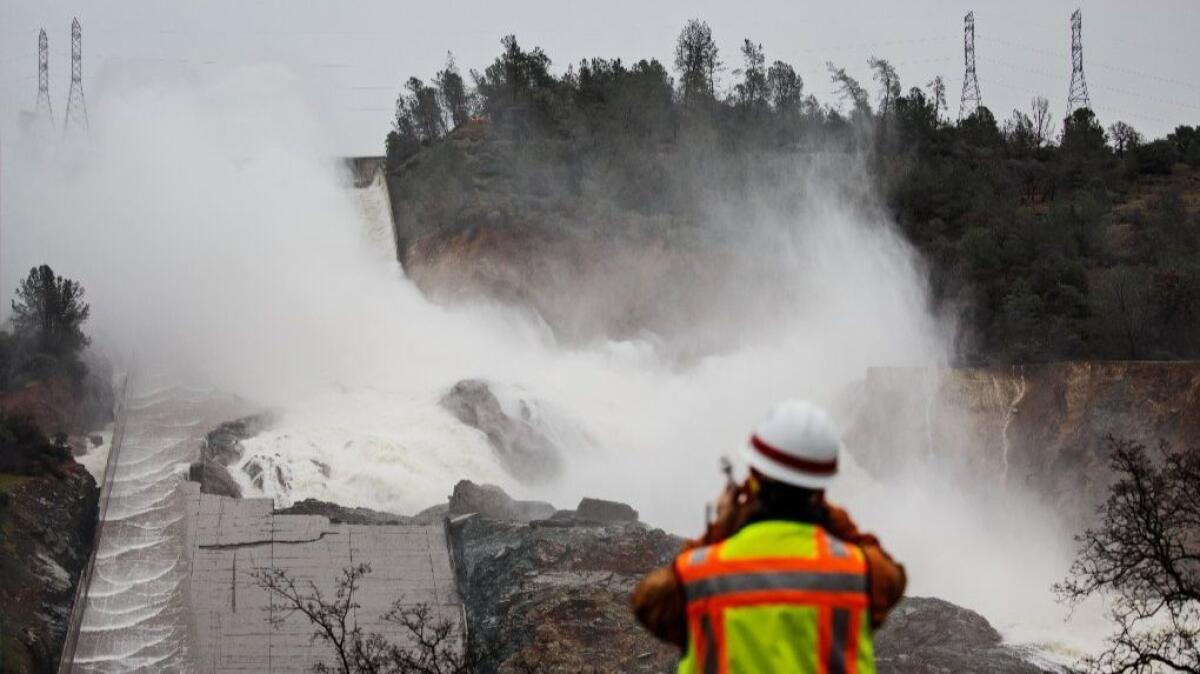
With reduced amounts of water surging down the main spillway on Sunday morning, the structural damage it sustained was clearly visible.
Its long, concrete chute was buckled and riven with deep cracks above and below the jagged hole hundreds of feet across.
Nearly all of the water being released down it was slamming into the hole, then cascading down a deep fissure that has opened up on a hillside shouldering the right side of the dam.
Orrock said the state agency hopes to have fully repaired the main concrete spillway at the facility, about 65 miles north of Sacramento in Butte County, “by the beginning of the next runoff season, which begins in September.”
As of Sunday, the costs of that effort combined with repair work on the dam’s emergency spillway had climbed to more than $10 million, according to a report reviewed by The Times. Repairs on both spillways could ultimately cost as much as $200 million or more, officials estimate.
Meanwhile, officials warned there is a high risk of flooding in parts of already-saturated Northern California as the latest storm moves in this week.
The National Weather Service said the highest risk for flooding was in a large swath of the region from Monterey to Marin County on the coast, then into the Sacramento Valley and Sierra Nevada.
The storm is expected to put added stress on levees, streams, creeks and rivers that are already approaching dangerously high water levels.
Parts of Northern California are already on track to have the wettest winter ever recorded.
The weather service warned that the San Joaquin River at Vernalis “has reached danger stage. Greater risk for levee problems.” Sandbagging operations were underway there as the storm approached.
Officials also said several other waterways were at major risk of flooding, including the Yolo Bypass, Clear Lake, and the Sacramento, Cosumnes, Mokelumne, Merced and Tuolumne rivers.
More to Read
Start your day right
Sign up for Essential California for news, features and recommendations from the L.A. Times and beyond in your inbox six days a week.
You may occasionally receive promotional content from the Los Angeles Times.


